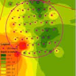
Subsurface Mapping
Geophysical plays a crucial rule is identifying Geohazard zones

Environmental Risk Assessment
Leverage geophysics for environmental risk assessments, enabling precise subsurface analysis to identify hazards, mitigate risks and support sustainable development

Hydro & Enviro Care
Geophysics empowers hydro and environmental care by offering advanced subsurface imaging techniques to manage water resources, assess soil health, and ensure ecological sustainability
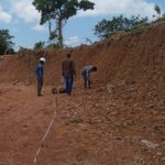
Seismic - MASW / Refraction
Applications: Seismic Site Characterization / VS 30/ Stratigraphy/ Hard rock or Weathered rock classification / Rock Mapping
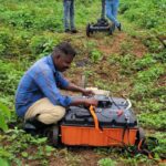
Electrical Resistivity Tomography
Appications: Ground water detection / Stratigraphy / Rock Mapping / Hard rock or weathered rock classification
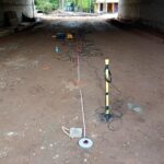
Ground Penetrating Radar
Applications: Utility detection / Infrastructure Inspection/ Detecting Voids/Foundation Assessment